The Old Bog Road is a popular walking route and gateway in the Slieve Aughtys. It starts on the N66 Gort- Loughrea
road and winds its way southwards https://711-casino.be/ and upwards into the hills for about 6km. It passes through several townlands
including Cloghaun, Ballyguneen, Gortnagleav and Kilnagappagh.
The road is lined with woodland and hedgerow at lower elevations, upland grassland and gorse scrub with blocks of coniferous forest as you move into the uplands and finally through a landscape with a patchwork of bog and heathland.
The Old Bog Road was probably built in the late 19th century to provide easier to access farmland and turf cutting plots. The big house in Kilchreest at the time was Roxborough House, occupied by the Persse family. Another significant house was Woodville House, which was occupied by the D’Arcy family from 1750 until the 1860s.
Woodville House was leased by Harry Persse in 1860 until 1916.
Families lived in the uplands for generations prior to the construction of the road but the number of people living
there declined markedly following the famine.
Several large Oak trees line the route at the start of the road. These majestic trees are a legacy of an Oak plantation
in neighbouring fields, to the east of the road, known locally as the ‘Green Wood’. The wood was owned by the
Persse family and the Roxborough estate had a sawmill. On the first edition 6” Ordnance Survey map (1842) for the
area, Ballyguneen townland is described as ‘under plantation’.
The wooded section of the Old Bog Road has a diverse mix of trees and shrubs including Oak, Beech, Ash, Hazel,
Rowan, Hawthorn and Holly. The woodland floor is carpeted with bluebells in springtime. The lucky walker might
also spot a Red Squirrel.
A small river, known locally as the Black River, flows parallel to the road for the first section of the route. According
to local folklore, St. Patrick stopped on this horse somewhere on the hill near the river as his horse skidded looking
for water. The river is generally fast-flowing and there are a few small waterfalls.
There is gate on the road for stock control. This mountain gate marks the transition from lowlands to uplands. Gorse
is more abundant along the road from this point in the hedges and on the hills. The surrounding fields are damp and
heathy.
The Peterswell-Kilchreest Gun and Conservation Club have been running a Red Grouse Conservation Project in the
area in recent years. They have been managing areas of Heather to favour the Red Grouse and controlling vermin
that prey on young birds, which also benefits many non-game species including the rare Hen Harrier and Merlin, as
well as Curlew, Snipe and Meadow Pipit.
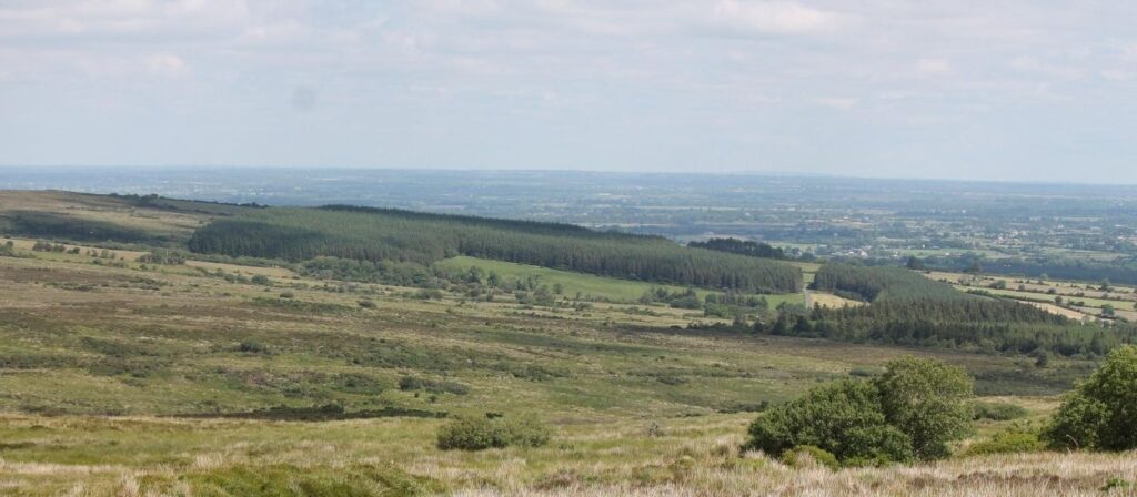
There is a viewing point at a bend in the road, locally known as ‘Lady’s View’. From here there are spectacular views
of south Galway. Several castles can be seen as you look northwards including Cloghaun, Castleboy (not really a
castle but the remnant of a big house), Issertkelly and Deerpark. The Burren hills in County Clare can be seen to the
west and on a fine day Croagh Patrick in Mayo can be seen to the north.
There are a couple of local stories as to the origin of the name. Some suggest that the ladies from the nearby
Roxborough estate liked to picnic at this spot on a day out. Another story reports that American visitors to the area
in 1961 commented that the view at this point on the Old Bog Road is better than Lady’s View in Killarney.
The upland townland of Gortnagleav Gort na gCliabh is known locally as ‘Field of the Sword’ although officially it is
translated to ‘Field of the Baskets’. Several old hut sites that were probably associated with booleying have been
recorded in this area.
Place names in the Aughties reflect this booleying history e.g. The Boleyneendorrish River(Abhainn Bhuaile an Aon Dorais) flows to the south of the end of the Old Bog Road. There are also the ruins of
sixteen houses or botháns in Gortnacleav, some under forestry.
Another townland, Kilnagappagh Coill na gCeapach translates to ‘Wood of the Plots’. At the time of the landlord
system, much of the uplands was let to tenants by allotments, not by the acre.
The bogland in the Kilchreest uplands is a haven for nature and wildlife. There is a rich tapestry of peaty habitats
including blanket bog, wet and dry heath, and wetlands known as ‘flushes’. One of the highlights of the uplands
around Kilchreest is the chance to see one our rarest and most beautiful birds of prey, Hen Harriers. They are often
seen by walkers along the upper reaches of the Old Bog Road in summer. Other birds of note in the area are Merlin,
Golden Plover, Snipe, Curlew and Woodcock. Large flocks of Golden Plover can be seen in winter.
The uplands are a haven for wildlife and walkers but they are also a working landscape that supports the local community with commonage farmland, forestry and turf cutting plots.
Credits
Elaine O’Riordan, Tom Varley (Slógadh Eachtaí), Gerry Daly, Dr Christy Cunniffe (County Galway Community Archaeologist) and Kevin Cunningham assisted with a heritage audit of the Old Bog Road (funded by the Heritage Council).